
|
|
|
|
|
|

|
Click arrow above to view Slideshow | |||||||||
THE COLUMBIA RIVER BASALT GROUP | |
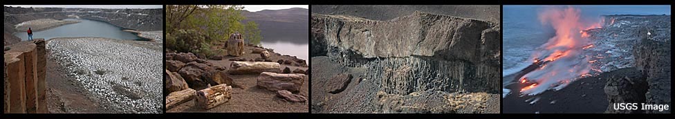
The Columbia Basin of eastern Washington is plastered with deep layers of a fine grained black rock known as basalt. The basalt is lava that cooled and hardened after it flooded over the landscape. These astounding lava floods occurred on a scale unequalled anywhere else on the entire planet. When we think of lava flows, images of Hawaii�s volcanoes come to mind. Oozing red masses, capped with smudgy gray outer surfaces, slowly drizzle down mountainsides like streams of molasses. This provides exciting volcano footage for television documentaries. But the lava outflows from Hawaiian volcanoes rank as puny by comparison to the volumes of molten material that bubbled up from below the surface in the Pacific Northwest�s interior regions. | 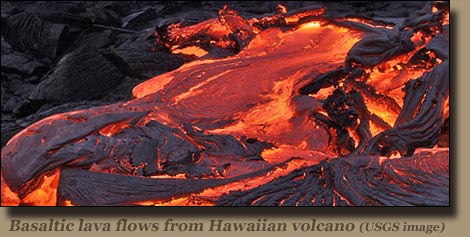 |
|
Lava began flowing in the Columbia Basin about 17 million years ago and continued until about 6 million years ago. In all, there may have been 300 individual outbreaks. Each lava flood was separated by thousands of years in which nothing happened. | |
|
The cumulative effect was staggering. By the time these eruptions ceased, most of the Columbia Basin was coated with basalt rock at least one mile thick. In the central and southern Yakima Valley the accumulated basalt measures three miles in depth. Flows of the so-called �Columbia River Basalt Group� covered virtually all of Washington state east of the Cascades and south of a line roughly following the Spokane River, Lake Roosevelt, and the Columbia River from Grand Coulee Dam until the river makes its bend at Pateros. Streams of basalt lava carved a wide path through the Columbia Gorge region and then on to the Pacific Coast. The Oregon coastal shoreline contains remnants of these flows in such prominent features as Tillamook Head. Extensive areas of northeast Oregon also were covered. [Other basalt outbreaks blanket southeast Oregon and the Snake River Plain in Idaho.] The coverage area for Columbia River flood basalts exceeds 60,000 square miles. At least 50,000 cubic miles of basalt can be found within that area, and some estimates go as high as 90,000 cubic miles. The immense weight of this rock caused the Earth�s outer crust to depress and form the shallow basin that dominates the topography of eastern Washington.
"What is lava?" - Click to play video. |
 Lava outflows from Hawaiian
| ||
WHAT DOES IT LOOK LIKE?At first glance all basalt looks alike. But there are subtle differences in color and composition. Certain basalts include more silica. Others contain crystals of olivine, and still others show evidence of exotic forms of feldspar. The differences enable scientists to isolate basalt type and their probable sources.Basalt exposed on the vertical walls of canyons, coulees, and buttes is visible as a closely-packed array of rock fence posts [or palisades]. These columns formed when the lava cooled and crystallized into basalt rock. When lava cools, it shrinks. This created vertical polygons, usually five-sided, and separated from their neighbors by cracks. This fracturing into columns occurs both from the top down and from the bottom up�but at different rates because the upper basalt exposed to the air cools faster and suffers more fractures. Since the pattern of column development is uneven, the fractures create a jumble where the lower and upper columns meet. [Another form is �pillow basalt, � which is created when lava encounters a body of water. The effects of a more rapid cool-down shape the lava into connected loaves or pillows.] The network of vertical fractures makes columnar basalt especially vulnerable to weathering, as evidence by the piles of broken rock at the bases of basalt outcroppings. The sheer power of the Ice Age floods stripped the outer layers of these basalt formations, while violent whirlpools within rapidly-moving and deep flood flows exerted enough force on any underlying basalt to rip chunks out of it.
 Frenchman Coulee | |||
 Standing on Columnar Basalt |
The Columbia River Basalt Group is subdivided into four formations:
| ||
WHY DO WE HAVE SO MUCH BASALT?The lava outflows apparently welled up through fissures in the earth�s crust. In the Grand Ronde River Valley�source of the most important basalt floods�these fissures typically are a few yards wide and several miles in length. Scientists speculate that about 20,000 of these fissures were sources for the Grande Ronde basalts. Lava eruptions typically lasted for several days to a few weeks, and the outflows were layered 50-100 feet deep. Depending upon the surrounding terrain, the floods moved at rates ranging from one-half mile per hour to about three miles per hour. The flows would have disrupted rivers�often forcing them into new channels. These watercourses sometimes eventually returned to their old locations as the �new basalt� was eroded to the earlier elevations of surface rock. | 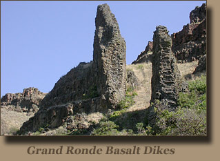 | ||
|
Scientists don�t agree as to what triggered these huge volcanic outbreaks. The regions basalt appears to have come from deep within the Earth�s crust. While the stresses normally present at boundaries between major plates which slowly drift in the crust region often cause volcanic eruptions, these normally produce outflows from shallow sources. Another possibility is the concept of volcanic �hot spots� such as the one at Yellowstone National Park. It is believed that similar hot spots were present millions of years ago in southern Oregon. Some explain the intensity of the outbreaks by speculating that a huge asteroid ramming into southeastern Oregon created so much heat and disruption that it could have set off these violent eruptions. Even those scientists who have their own explanations are not fully satisfied with them. We may never know.
A TREASURE TROVE OF GEOLOGIC HISTORY | |||
|
Hundreds of eruptions--each separated by thousands of years--leave us with a unique record of conditions millions of years ago. During periods of volcanic inactivity, water would accumulate in depressions, sediment would accumulate in valleys, and wind would deposit dust. Soil layers would develop and forests and grasslands would flourish. Plants and animals would appear. The next cycle of lava flows would would abruptly terminate their existence, but preserve a fossil record. At some point during the Miocene Epoch the Columbia Basin was home to an aquatic rhinoceros, huge turtles, small three-toed horses, deer, bear, camels and elephants. The late Miocene/early Pliocene period leaves evidence of horses, raccoons, badgers and coyotes.  Fifteen million years ago there were spruce, oak, maple, willow and bald cypress trees in the region--and the fossils from magnolia and bald cypress trees are so good that DNA samples can be taken from them. The Wanapum flows [14.5 to 13 million years ago] , overturned and entombed entire trees, leaving us with such phenomena as Ginkgo Petrified Forest State Park at Vantage, Wash. (see Ginkgo image at top of page). | ||


)
)