HUGEfloods.com Home Page Not much time? ... Click here for a quick Ice Age Floods summary Ice Age Floods Feature of the month For many years one man understood the clues but no one would listen Glacial Lake Missoula Channeled Scablands of Eastern Washington Temporary Lake Lewis Columbia Gorge Explore the variety of features created by the Ice Age Floods Columbia River Basalt Group The Pleistocene Grand Coulee Dam and the Columbia Basin Irrigation Project Washington Wines Ice Age Floods Institute

December 2008

Spring Coulee - Billy Clapp Lake

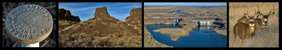
"Spring Coulee is a fine scabland canyon, with castle-like buttes, lateral subsidary canyons, and cataracts notching its walls" J Harlen Bretz (1932)

One of many potholes near Billy Clapp Lake that were scoured out by the Ice Age Floods.
One of many potholes scoured out by the Ice Age Floods above Billy Clapp Lake

Click to view trip reports from recent hikes into Spring Coulee:

Spring Coulee (East)

Spring Coulee (West)

Looking northwest to the upper end of Spring Coulee (Billy Clapp Lake).


All photos by Tom Foster unless otherwise noted.

HOME Space CONTACT Space SITE MAP IAFI Space LINKS Space © 2008
Ellensburg
Lake Missoula
Lake Lewis
Ice Age Blog
Ice Age Express
Feature of the Month
The Mystery
25 Features
Channeled Scablands
Ice Age Floods Videos
Columbia Gorge
Feature Types
Columbia River Basalt
The Pleistocene
Grand Coulee Project
Washington Wine
Ice Age Floods Inst.
The Bonneville Flood