HUGEfloods.com Home Page Not much time? ... Click here for a quick Ice Age Floods summary Ice Age Floods Feature of the month For many years one man understood the clues but no one would listen Glacial Lake Missoula Channeled Scablands of Eastern Washington Temporary Lake Lewis Columbia Gorge Explore the variety of features created by the Ice Age Floods Columbia River Basalt Group The Pleistocene Grand Coulee Dam and the Columbia Basin Irrigation Project Washington Wines Ice Age Floods Institute

Wenatchee WA - Ice Age Flood Features

Central Washington University geologist Nick Zentner explains Wenatchee area features created by the Ice Age Floods - Click arrow to play video.

Additional episodes available at: " 2 Minute Geology"


Ice Age Floods at Wentachee, Washignton by Stev Ominski.
"Above Wenatchee" by Ice Age Floods artist Stev Ominski.

Floodwater in the Wenatchee Valley traveling up to 65 miles-per-hour and 1,000 feet deep! With icebergs rafting massive boulders.

Evidence Left by the Ice Age Floods Surrounds Wenatchee

Wenatchee, Washington - first established at the confluence of the Columbia and Wenatchee Rivers - is nestled among beautiful landforms strongly imprinted by the Ice Age Floods of the Pacific Northwest. The floods did massive amounts of work here, but not in a way that most of us visualize. Instead of the more familiar coulee-cutting erosion by the floods, the story in Wenatchee are the Ice Age Floods depositing layers of sediment, rocks, and even house-sized boulders!

Wenatchee area Ice Age Floods tour map.
Click to request Wenatchee Valley Visitors Bureau: Ice Age Floods Tour Map.

Approximate limits of flooding during Ice Age Flood events near the site of Wenatchee, WA.
Blue lines mark Columbia (large) and Wenatchee rivers. Approximate limits of Ice Age Flooding shown.

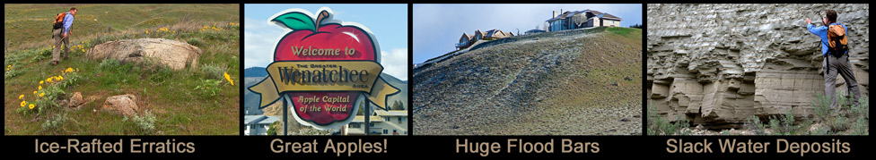
Huge boulders shown in column at right were deposited by the Ice Age Floods. Top two images show boulders on private property [photos taken from city streets]. Boulders in lower photo sit near Columbia River pedestrian bridge - along bike path.


Wenatchee Area
Ice Age Flood Story

During much of the Pleistocene Epoch, the Okanogan Ice Sheet covered much of north central Washington and blocked the Columbia River north of Wenatchee. As a result, the Wenatchee area did not experience the intense flood erosion experienced elsewhere in Washington. Coulee walls do not tower over Wenatchee. But during times when the ice sheet was smaller in northern Washington, tremendous volumes of water came surging down the Columbia River and the Ice Age flood deposits at Wenatchee were laid down.

Giant flood bars, ice-rafted erratics, fine-grained slack water sediments - these are the features on display in Wenatchee. And the scale of these landforms are truly breathtaking! Pangborn Bar is the king of the region - a giant flood bar 600 feet high. The Ice Age Floods over Wenatchee were 1000 feet deep and traveling quickly down the Columbia!

And it wasn't just floodwater. There were large rafts of ice - broken pieces of the Okanogan Lobe - that floated in on the water carrying large boulders from the north. Ice-rafted erratics of gneiss, granite, and other foreign rocks now litter the local landscape. They are well-traveled boulders that help mark the extent of the floods - not only over Wenatchee, but also plenty of quiet water that worked its way up the Wenatchee River Valley to Cascade town of Leavenworth!

Ice Age Flood erratics near Wenatchee, WA.

Rocky-Reach-Dam on the Columbia River near Wenatchee, WA.

Alternate US97 along Columbia River [1] north of Wenatchee and Rocky Reach Dam [2]. Point "3" in the distance is the approximate location where most of the floodwater turned east (left) and inundated the site of present day Wenatchee. Some of the floodwater was forced west (right) at location marked "3" and filled the Wentachee River valley all the way to Leavenworth, WA.


Wentachee River, Columbia River confluence from East Wenatchee, Washington.
Confluence of Wenatchee and Columbia Rivers. View from top of Pangborn Bar (East Wenatchee, WA)

Wenatchee Valley - East.
Lower Pangborn Bar [1] and site of Rock Island Dam [2] downstream from Wenatchee.

BLM Geologist Brent Cunderla.

Wenatchee IAFI Chapter President - BLM Geologist Brent Cunderla

Photo at left shows Cunderla in the field with University of Arizona geologist Vic Baker. Cunderla [black jacket] examining slack water flood deposits in second image with Nick Zentner [Ellensburg IAFI Chapter President].

In addition to Cunderla, several other Wenatchee area residents work hard to promote the Ice Age Floods story - a couple of them [I've met] are Ralph Dawes and Ken Lacy. Thanks guys!!!

Learn more about Wenatchee area Ice Age Flooding


Click apple to open Ice Age Floods Institute Chapter Page
Columbia River Basalt in Drumheller Channels, shaped by the Ice Age Floods.

All photos by Tom Foster unless otherwise noted.

HOME Space CONTACT Space SITE MAP IAFI Space LINKS Space © 2008
Ellensburg
Lake Missoula
Lake Lewis
Ice Age Blog
Ice Age Express
Feature of the Month
The Mystery
25 Features
Channeled Scablands
Ice Age Floods Videos
Columbia Gorge
Feature Types
Columbia River Basalt
The Pleistocene
Grand Coulee Project
Washington Wine
Ice Age Floods Inst.
The Bonneville Flood