HUGEfloods.com Home Page Not much time? ... Click here for a quick Ice Age Floods summary Ice Age Floods Feature of the month For many years one man understood the clues but no one would listen Glacial Lake Missoula Channeled Scablands of Eastern Washington Temporary Lake Lewis Columbia Gorge Explore the variety of features created by the Ice Age Floods Columbia River Basalt Group The Pleistocene Grand Coulee Dam and the Columbia Basin Irrigation Project Washington Wines Ice Age Floods Institute

Basaltic lava erupts at nearly 2,000 degrees and is the most common rock in the world.


Express Tour - Section I

Fire & Ice Set the Stage for Ice Age Floods

Summary of the spectacular catastrophic floods that raged through eastern Washington and the Columbia Gorge at the end of the most recent Ice Age

USGS Photo of lava flow advancing over the coastal plain of Kîlauea in Hawaii, United States.
USGS Image of Basaltic Lava advancing over the coastal plain of Kilauea in Hawaii. Most Hawaiian flows are less than three feet thick. Many of the Columbia River Basalt Group flows were more than 100 feet thick.


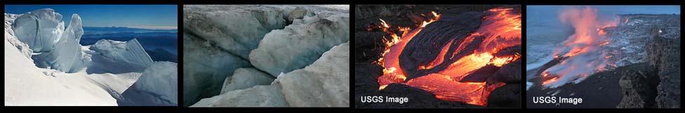
BEFORE THE ICE-AGE FLOODS CAME...THE LAVA FLOWED

Columbia River Basalt Group Map
Columbia River Basalt flows spread over large portions of Washington, Oregon and Idaho.

About 17 million years ago floods of lava began coating the Columbia Basin of Washington--as well as northeast Oregon, and the Columbia Gorge region all the way to the Pacific Coast. Originating from hundreds of lengthy fissures in northeast Oregon, as many as 300 separate floods deposited thick lava beds over 60,000 square miles. The lava outbreaks ceased about 6 million years ago. Each lava flood cooled and hardened into dark basalt rock which accumulated to a mile in depth throughout much of the region.

Columbia River Basalt Dikes and Basaltic Lave Flow, USGS Image
Basalt Dikes (left) and Basaltic Lave Flow (Hawaii)


Click arrow above to view Slideshow


GLOBAL COOLING THEN BRINGS AN ONSLAUGHT OF ICE-AGE GLACIERS

Glacial Ice USGS Image.

Between 2 million and 2.5 million years ago a combination of cooler temperatures and increased precipitation formed massive ice sheets which repeatedly advanced and retreated as climate conditions fluctuated. Ice coated the Puget Sound lowlands, and most of the mountain regions of northern Washington, Idaho and Montana. So much glacial ice existed that the oceans were 300 feet lower than they are today. The final episode was the Wisconsin glaciation, a cycle that took place from 100,000 years ago until about 10,000 years ago.


Ice Age Floods Express Tour: Continue

Section I
Lava Flows
Ice Age
Section II
Ice Dam
Lake Missoula
Section III
Scabland Floods
Wallula Gap
Section IV
Columbia Gorge
To the Pacific
Section V
Evidence
Solving the Mystery


Columbia River Basalt in Drumheller Channels, shaped by the Ice Age Floods.

All photos by Tom Foster unless otherwise noted.

HOME Space CONTACT Space SITE MAP IAFI Space LINKS Space © 2008
Ellensburg
Lake Missoula
Lake Lewis
Ice Age Blog
Ice Age Express
Feature of the Month
The Mystery
25 Features
Channeled Scablands
Ice Age Floods Videos
Columbia Gorge
Feature Types
Columbia River Basalt
The Pleistocene
Grand Coulee Project
Washington Wine
Ice Age Floods Inst.
The Bonneville Flood