
|
|
|
|
|
|


|
Express Tour - Section IIIce Dam Blocks the Clark Fork River

|
ICE DAMS BLOCK MOUNTAIN VALLEYS, CREATING SUPER-RESERVOIRS | |
 Map by Bruce Bjornstad showing Ice Dam that blocked the Clark Fork River. Note outline of modern day Lake Pend Oreille.
| As the ice sheets pushed southward from Canada they interrupted normal stream flows in the deep valleys of the mountainous Pacific Northwest. One protrusion, the Okanogan Lobe, created Lake Columbia, which was a super-sized version of modern Lake Roosevelt. An ice mass clogging the Purcell Valley of Idaho's panhandle blocked the outflow of the Clark Fork River, forming Glacial Lake Missoula. Other impoundments included a lake near Spokane, Wash. Scientists believe that additional lakes existed in Washington, Montana and British Columbia. |

| |
LAKE MISSOULA BECOMES A CATALYST FOR A CATASTROPHE | |
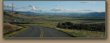 Image shows Little Bitterroot Valley in western Montana. Huge valleys in western Montana combined to store over 500 cubic miles of water. | The ice blockage in the Purcel Valley gradually collected tremendous volumes of water in the deep valleys of western Montana, creating a gigantic reservoir which attained a depth of 2,000 feet and impounded over 500 cubic miles of water--equivalent to the combined volumes lakes Erie and Ontario. The natural ice dam periodically failed, which caused a catastrophic emptying of Lake Missoula. After each dam failure, the southward moving ice sheet then created a new one, and the cycle repeated itself. At least 40 major flood episodes originated from Lake Missoula. |
 |
Ice Age Floods Express Tour: Continue | ||||
